Gauge Plates
 Gauge Plates
Gauge Plates measure flood water depth over the road. They are sometimes referred to as flood depth marker signage.
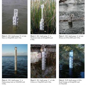
Photographs 1-6: SWWMP Depth Gauges. Each depth gauge consists of one or more 1.00m metal or plastic gauge plates attached to a metal or wooden post. The gauge plate markings are in 0.01m increments, with labelling at 0.10m intervals. Labels 1,2, 3, etc., at the top of each depth gauge indicate the height in metres (i.e. 1.00m, 2.00m, etc.) at the top of the uppermost gauge plate.
Labels A, B, C, etc., where present, identify individual depth gauges at each wetland.
DEC gauge readings indicate the water depth at the deepest location in the wetland, even though gauges are usually not at the deepest location, but instead are closer to the shore, to facilitate viewing.
Readings are taken from Department of Water (DoW) gauges at several metropolitan wetlands. These DoW gauges indicate height above Australian Height Datum (mean sea level), which SWWMP personnel convert to wetland water depth.
Since 2007, the standard practice of SWWMP personnel when taking gauge readings has been to take a digital photograph of the gauge at the time of reading, so that all records may be checked and verified or corrected back in the office.
Contact us now for a quote.